Ambon (Indonesian pronunciation: [ˈambɔn]; formerly Dutch: Amboina) is the capital and largest city of the Indonesian province of Maluku. This city is also known as Ambon Manise, which means “beautiful” or “pretty” Ambon in the Ambonese language. It covers a land area of 359.45 square kilometres (138.78 sq mi), and had a population of 331,254 at the 2010 Census[2] and 347,288 at the 2020 Census;[3] the official estimate as of mid 2024 was 357,289.[1] The city is divided into five administrative districts (kecamatan) – namely Nusaniwe, Sirimau, Teluk Ambon (Ambon Bay), Baguala (officially Teluk Ambon Baguala) and Leitimur Selatan (South Leitimur). Known as Indonesia’s music city,[4][5][6] Ambon became the first city in Southeast Asia to be recognised as the UNESCO City of Music in 2019.[7]
History
Portugal (1513–1605)
VOC (1605–1796)
Great Britain (1796—1800)
United Kingdom (1800–1803)
Dutch East Indies (1803–1811)
Japan (1942–1945)
Indonesia (1949–present)[c 1]
Origin of the name
The origin of the term “Ambon” is not easily determined. According to local accounts, the term is derived from the word embun (mist/dew).[8] The mountain peaks on Ambon Island are indeed frequently covered by thick mist. The term Laha was also once used to name the Fort of Nossa Senhora da Anunciada, which became the precursor of the [9]In the local language, laha is translated as “harbor.”[10]
Although the term “Ambon” now refers to Ambon City, Ambon Island, or the Ambonese people, throughout history (especially in the 20th century), it referred to the inhabitants of Central Maluku. The phrase “Ambonese people” (Ambonezen) itself referred to the residents of Central Maluku, even though it was originally only used for the inhabitants of Ambon City who possessed a mestizo culture.[11]
Fort Victoria


Ambon City began to develop following the arrival of the Portuguese in 1513.[13] Later, around 1575, Portuguese authorities mobilized the local population to build the Kota Laha Fort (also known as the Ferangi Fort), which was originally named Nossa Senhora da Anunciada, located on the Honipopu Plain.[14] During its construction, the workers established village-like organizations such as Soya, which became the foundation of Ambon City. This was because, in its subsequent development, these groups evolved into an organized territorial genealogical society.[15]
Dutch period
After the Dutch successfully seized the Maluku Islands and specifically Ambon from Portuguese control, the Nossa Senhora de Anunciada fort was captured in 1605 and turned into the center of colonial administration under the name Victoria. Following a severe earthquake that caused heavy damage, the fort was renovated and renamed Nieuw Victoria, though it remained better known among locals as Fort Victoria. This fort is historically significant as the site where the national hero Pattimura was executed by hanging on 16 December 1817.[16]
Ambon Island was conquered by the Dutch East India Company (VOC) on 23 February 1605, with military assistance from Ternate, Luhu, Hitu and Gowa. During the early VOC era, several governors held power, including the authoritarian Adrian Martensz Block, who utilized forced labor to expand Fort Victoria, and Herman van Speult, who oppressed the people through spice trade monopolies.[17]
On 17 February 1796, the VOC surrendered to British Admiral Pieter Ramier, making Ambon part of British territory until 1803. Afterward, control was handed back to the Dutch government (rather than the VOC, which had gone bankrupt in 1799). During the Dutch East Indies era, Ambon underwent modernization. Fort Victoria became the capital of the Government of Amboina, part of the Government der Molukken established in 1817. On 7 September 1921, the people of Ambon were granted equal rights to the colonial government, marking a political victory for the local struggle and allowing them to play a role in governance.[18]
Japanese occupation
Japanese troops landed in Ambon on 1 February 1942. They defeated the Dutch and their allies in the Battle of Ambon to seize the city, which served as a strategic naval and air base. During this occupation, citizens suffered from poverty and famine due to the war. Remnants of this era can still be found today, such as the Ambon War Cemetery for Allied soldiers and Japanese torpedoes discovered at the bottom of Ambon Bay.[19]
Indonesian independence
The anniversary of Ambon City was officially set as 7 September 1575. This date was determined during a 1972 seminar involving Pattimura University. The year 1575 commemorates the start of the construction of Fort Kota Laha, while the date 7 September honors the day in 1921 when Ambon citizens achieved equal political rights. The city’s anniversary was first celebrated on 7 September 1973.[20]
Geography and climate
Topography
Most of the land area can be classified as hilly to steeply sloping, while 17% of the land area can be classified as more flat or shallow-sloped.[21]
Climate
Ambon experiences a tropical rainforest climate (Af) according to Köppen Climate Classification as there is no real dry season. The driest month is November with total precipitation of 114 mm (4.5 in), while the wettest month is June with total precipitation of 638 mm (25.1 in). As it is located near the equator, the temperature throughout the year is constant. The hottest month is December, with an average temperature of 27.2 °C (81.0 °F), while the coolest month is July, with an average temperature 25.0 °C (77.0 °F).[22]
| Climate data for Ambon, Maluku, Indonesia (Extremes: 1912-1936) | |||||||||||||
|---|---|---|---|---|---|---|---|---|---|---|---|---|---|
| Month | Jan | Feb | Mar | Apr | May | Jun | Jul | Aug | Sep | Oct | Nov | Dec | Year |
| Record high °C (°F) | 35.5 (95.9) |
35.5 (95.9) |
35.0 (95.0) |
33.9 (93.0) |
32.3 (90.1) |
30.5 (86.9) |
30.0 (86.0) |
30.5 (86.9) |
31.1 (88.0) |
32.8 (91.0) |
34.4 (93.9) |
35.5 (95.9) |
35.5 (95.9) |
| Mean daily maximum °C (°F) | 31.3 (88.3) |
31.4 (88.5) |
31.1 (88.0) |
30.7 (87.3) |
29.8 (85.6) |
28.5 (83.3) |
27.5 (81.5) |
27.8 (82.0) |
29.1 (84.4) |
30.3 (86.5) |
31.1 (88.0) |
31.5 (88.7) |
30.0 (86.0) |
| Daily mean °C (°F) | 27.0 (80.6) |
27.0 (80.6) |
26.9 (80.4) |
26.7 (80.1) |
26.4 (79.5) |
25.6 (78.1) |
25.0 (77.0) |
25.1 (77.2) |
25.7 (78.3) |
26.5 (79.7) |
27.0 (80.6) |
27.2 (81.0) |
26.3 (79.3) |
| Mean daily minimum °C (°F) | 24.1 (75.4) |
24.1 (75.4) |
23.8 (74.8) |
23.9 (75.0) |
24.0 (75.2) |
23.6 (74.5) |
23.2 (73.8) |
23.1 (73.6) |
23.3 (73.9) |
23.8 (74.8) |
24.1 (75.4) |
24.2 (75.6) |
23.8 (74.8) |
| Record low °C (°F) | 22.2 (72.0) |
22.8 (73.0) |
22.2 (72.0) |
21.6 (70.9) |
20.0 (68.0) |
20.5 (68.9) |
20.0 (68.0) |
19.4 (66.9) |
18.9 (66.0) |
18.9 (66.0) |
21.1 (70.0) |
20.0 (68.0) |
18.9 (66.0) |
| Average rainfall mm (inches) | 127 (5.0) |
119 (4.7) |
135 (5.3) |
279 (11.0) |
516 (20.3) |
638 (25.1) |
602 (23.7) |
401 (15.8) |
241 (9.5) |
155 (6.1) |
114 (4.5) |
132 (5.2) |
3,459 (136.2) |
| Average rainy days | 12 | 13 | 12 | 12 | 19 | 21 | 22 | 21 | 16 | 10 | 10 | 13 | 181 |
| Average relative humidity (%) | 79 | 80 | 83 | 85 | 87 | 86 | 85 | 84 | 83 | 81 | 80 | 82 | 83 |
| Mean monthly sunshine hours | 192 | 186 | 211 | 177 | 158 | 120 | 115 | 112 | 150 | 192 | 219 | 202 | 2,034 |
| Source 1: Deutscher Wetterdienst[22] | |||||||||||||
| Source 2: Danish Meteorological Institute[23] | |||||||||||||
Government
Ambon City was established under Law Number 60 of 1958, enacted on 17 July 1958. It is part of the Maluku Province and holds the status of a city in Indonesia. Similar to other Indonesian cities, its administration is divided into three levels: city, district (kecamatan), and sub-district (kelurahan) or village (desa). As part of the Maluku Islands, some villages in the city are also known by the traditional term negeri. [24]
The city administration is led by a Mayor who is accountable to the Ambon City Regional House of Representatives (DPRD), in accordance with Government Regulation Number 108 of 2000. Both the Mayor and Vice Mayor are based at the Ambon City Hall. The administration is also supported by the DPRD, whose members are elected by the people. Administratively, Ambon is divided into 5 districts, which are further subdivided into 50 sub-districts and villages. The largest district is Sirimau, with a population of 178,611, while the smallest is South Leitimur, with 11,862 residents (as of 2016).[25]
The Mayor
The Mayor serves as the highest leader within the Ambon City government. The Mayor of Ambon is titled Upu Latu Lette Kota Nusa Yapono, where Nusa Yapono refers to the traditional name given to the city by the community. Currently, the city is led by Mayor Bodewin Wattimena and Vice Mayor Elly Toisutta, who won the 2024 Ambon Mayoral Election.[26]
| No | Mayor | Term Start | Term End | Period | Notes | Vice Mayor | ||||
|---|---|---|---|---|---|---|---|---|---|---|
| 15 | 
|
Bodewin Wattimena | 22 May 2017 | Incumbent | 17
(2017) |
[ket. 1] | 
|
Elly Toisutta | ||
Administrative districts
The city is divided into five districts (kecamatan), tabulated below with their areas and their 2010 Census[2] and 2020 Census populations,[3] together with the official estimates as at mid 2024.[1] The table also includes the locations of the district administrative centres, the number of administrative villages and subdistricts (kelurahan) in each district (totaling 20 urban kelurahan, 20 negari and 10 rural desa), and its post codes.
| Kode Wilayah |
Name of District (kecamatan) |
Area in km2 |
Pop’n Census 2010 |
Pop’n Census 2020 |
Pop’n Estimate mid 2024 |
Admin centre |
No. of villages |
Post code |
|---|---|---|---|---|---|---|---|---|
| 81.71.01 | Nusaniwe | 88.35 | 89,866 | 90,250 | 91,574 | Amahusu | 13 (a) | 97114 – 97118 |
| 81.71.02 | Sirimau | 86.81 | 140,064 | 146,426 | 148,742 | Karang Panjang | 14 (b) | 97121 – 97129 |
| 81.71.03 | Teluk Ambon Baguala | 40.11 | 53,472 | 57,591 | 61,271 | Passo | 7 (c) | 97231 – 97233 |
| 81.71.04 | Teluk Ambon (Ambon Bay) |
93.68 | 38,451 | 43,363 | 45,495 | Wayame | 8 (d) | 97233 – 97237 |
| 81.71.05 | Leitimur Selatan (South Leitimur) |
50.50 | 9,401 | 9,658 | 10,207 | Leahari | 8 (e) | 97129 & 97237 |
Notes: (a) comprising 8 kelurahan and 5 negeri. (b) comprising 10 kelurahan, 3 negeri and one desa.
(c) comprising 1 kelurahan, 2 negeri and 4 desa. (d) comprising 1 kelurahan, 2 negeri and 5 desa. (e) all negeri.
Like other regions in the (Maluku Islands), areas in Ambon are still considered to have the status of states, led by kings and queens.
| District | States |
|---|---|
| Nusaniwe | Urimessing, Benteng, Wainitu, Kudamati, Waihaong, Manggadua, Nusanive, Amahusu, Latuhalat, Seilale |
| Sirimau | Waihoka, Amantelu, Rijali, Karangpanjang, Batumeja, Batugajah, Ahusen, Honipopu, Uritetu, Pandankasturi, Galala, Hative, Batumerah, Soya |
| Teluk Ambon Baguala | Waiheru, Nania, Negrilama, Passo, Lateri, Latta, Halong |
| Teluk Ambon (Ambon Bay) |
Laha, Tawiri, Greater Hative, Wayame, Rumatiga, Tihu, Poka, Hunuth |
| South Leitimor | Hatalai, Naku, Kilang, Ema, Hukurila, Hutumuri, Rutong, Leahari |

Baguala
Religion

According to the Regional Office of the Ministry of Religious Affairs for Maluku Province, as of 2022, the largest religious group in Ambon City is Christian at 59.41%, consisting of Protestants (56.93%) and Catholics (2.48%). This is followed by Islam at 40.47%, Hinduism at 0.08%, Buddhism at 0.34%, and Confucianism and others at less than 0.01%. Ambon is a Protestant-majority city. [28]
In 2021, there were 294 Protestant churches and 39 Catholic churches in the city. The largest Protestant church building is GPM Maranatha, while the largest Catholic church is the Saint Francis Xavier Cathedral. Additionally, GPM Silo serves as one of the city’s primary Protestant churches. The majority of the city’s Protestant community are members of the Protestant Church of Maluku (GPM). Ambon also has its own Roman Catholic diocese, the Diocese of Amboina. The districts with a Christian majority are Nusaniwe, Baguala, and South Leitimur, where Protestantism is the dominant religion.[29]

The city also has a large Muslim population, accounting for 40.47% of residents based on 2022 data. In 2021, there were 168 mosques; one of the largest is the Al-Fatah Grand Mosque, while the oldest is the Ambon Jami Mosque, built in 1860. Ambon City is also the largest contributor of Hajj pilgrims in Maluku, with 245 pilgrims in 2014. The districts where Islam is the dominant religion are Sirimau and Ambon Bay.[30]
Ambon City also has other minority religious populations in very small numbers, namely Hinduism, Buddhism, and Confucianism. Although their numbers are small, these three religions receive government attention. In 2018, President Joko Widodo inaugurated the Hindu Center and Buddha Center in Ambon City. This was done to fulfill the Maluku Governor’s wish for Maluku to become a laboratory for religious harmony in Indonesia. A well-known temple (pura) in the city is Pura Stana Giri Ciwa, while the famous Buddhist temple (wihara) is Wihara Swarna Giri Tirta. The city also has a very small number of Confucian followers, recorded as 7 individuals in the 2010 Indonesian Population Census.[31]
Economy

Economic growth rate of Ambon City in 2014 was 5.96%. Gross Domestic Regional Product in 2014 both at current market price and at constant market price was increasing gradually. The increase, if compared to 2013 GDRP at current market price equal to 12.76 percent and 5.96 percent for GDRP at constant market price. The GDRP at current market price in Ambon 2014 was equal to Rp.9.9 trillion, whereas for GDRP at constant 2010 market price, it was equal to Rp.7.77 trillion.[33]
In 2014, the gross domestic product per capita of Ambon based on current prices grew by 8.3 percent, while for the constant price in Ambon City grew by 1.7 percent. GDP per capita of Ambon City in 2014 is 25.16 Million (U $1,836.43). The poverty rate in the city of Ambon is 4.42% which is the smallest percentage of poverty in the province of Maluku.[33]
All twenty one economic sectors in 2014 saw positive growth for GDRP of Ambon. For GDRP at current market price, the highest contribution was provided by the electricity and gas Sector with 34.2 percent, while the lowest was human health and Social Work activities with 6.61 percent.[34]
Education

Education in Ambon City was recorded to have begun with the establishment of MULO in 1947, a Secondary School in 1946, and the Algemeene Middelbare School in 1946. In 1951, these schools were replaced by 104 junior high schools (44 public, 47 private, 8 aided, and 5 subsidized), senior high schools, and vocational high schools.The average length of schooling for Ambon’s residents is 11.64 years, equaling Singapore and France, with a school expectancy of 15.9 years, which approached Switzerland’s figures in 2016. Thus, in these two aspects, the city has matched other developed nations.[35]

Ambon is home to several prominent higher education institutions located in the city, such as Pattimura University (Unpatti) and Ambon State Polytechnic, both situated in Ambon Bay. Although the city’s higher education institutions are not among the best in Indonesia, the two best universities mentioned are still categorized in Cluster 3, with Ambon State Polytechnic ranked 186th and Pattimura University ranked 282nd according to Kemenristekdikti.[36]
Efforts to improve education have also been carried out through various programs, including scholarships. The city government has provided study scholarships to Japan for students—distributed across Maebashi, Fukuoka, and other cities in collaboration with the Kyoto government—and to India for civil servants. However, there was a case of a master’s degree scholarship scam that victimized a Unpatti student, though it did not originate from the government.[37]
Places of interest

Natural tourism
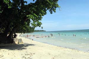
Ambon has many natural tourist attractions, though administratively, most of the highly famous sites are located in the Central Maluku Regency but are accessed through Ambon City. Among the beaches on Ambon Island, the most famous is Natsepa Beach, located in Suli Village, Central Maluku, which is well-known for its rujak natsepa. Additionally, there is Liang Beach, situated in Liang, Sala Hutu, Central Maluku.[38]
For diving activities, there is Nusa Pombo, an island located between Ambon Island and Haruku Island. On the other hand, famous tourist spots within the city’s administrative area are fewer and not as renowned as those in the regency, yet they are no less beautiful. Among the most famous is Pintu Kota Beach. Pintu Kota Beach is famous for its uniqueness, featuring a large hole that pierces through a coral cliff, passing through both sides. There is also Namasua Beach located in Naku, which remains relatively unknown. Besides beaches, there is Anihang Waterfall in Naku, which was once mentioned by Mayor Richard.[39]
-
 Pantai Natsepa
 -
 Pantai Liang
 -
 Bawah laut Nusa Pombo
 -
 Pantai Pintu Kota
 -
 Pantai Namasua


Historical tourism
In Ambon City, there is a museum called Museum Siwalima. Inside the Museum Siwalima, there are collections of historical objects.[40]
-
 Pattimura Statue
 -
 Siwalima Museum
 -

-

-
 Martha Christina Tiahahu Statue


Gallery
-
 City view during the day
 -
 Ambon at night


Transportation
Ambon is served by Pattimura International Airport.
Twin towns – sister cities
- Darwin, Australia
- Vlissingen, Netherlands
References
- ^ a b c Badan Pusat Statistik, Jakarta, 28 February 2025, Kota Ambon Dalam Angka 2025 (Katalog-BPS 1102001.8171)
- ^ a b Biro Pusat Statistik, Jakarta, 2011.
- ^ a b Badan Pusat Statistik, Jakarta, 2021.
- ^ “Bekraf canangkan Ambon kota musik dunia”. 28 July 2016. Archived from the original on 18 October 2019. Retrieved 18 October 2019.
- ^ “Menuju Kota Musik Dunia, Ketua DPR RI Resmikan Dua Gedung Musik di Ambon | TERASMALUKU.COM | Semua Membacanya”. Archived from the original on 18 October 2019. Retrieved 18 October 2019.
- ^ “Lantik DPD PAPPRI, Tantowi Yahya Akui Ambon Kota Musik”. 27 May 2013. Archived from the original on 18 October 2019. Retrieved 18 October 2019.
- ^ “UNESCO designates 66 new Creative Cities | Creative Cities Network”. Archived from the original on 1 February 2021. Retrieved 31 October 2019.
- ^ Leirissa, R. Z.; Latuconsina, Djuariah (January 1999). Sejarah Kebudayaan Maluku. Direktorat Jenderal Kebudayaan. ISBN 978-979-9335-07-4.
- ^ city.https://maps.wikimedia.org/img/osm-intl,a,a,a,250×200.png?lang=id&domain=id.wikipedia.org&title=Kota_Ambon&revid=29110956&groups=_40a7e1ecc07fb24d6a024501452ffcb8f344ac10&parser=parsoid
- ^ Leirissa, R. Z.; Latuconsina, Djuariah (January 1999). Sejarah Kebudayaan Maluku. Direktorat Jenderal Kebudayaan. ISBN 978-979-9335-07-4.
- ^ Leirissa, R. Z.; Latuconsina, Djuariah (January 1999). Sejarah Kebudayaan Maluku. Direktorat Jenderal Kebudayaan. ISBN 978-979-9335-07-4.
- ^ “Cemetery”. Commonwealth War Graves Commission. Archived from the original on 5 December 2017. Retrieved 5 December 2017.
- ^ Ricklefs, M.C. (1991). A History of Modern Indonesia Since c.1300, 2nd Edition. London: MacMillan. hlm. 25. ISBN 0-333-57689-6.
- ^ “Portal – Pemerintah Provinsi Maluku”. Archived from the original on 5 December 2017.
- ^ “Portal – Pemerintah Provinsi Maluku”. Archived from the original on 5 December 2017.
- ^ Ricklefs, M.C. (1991). A History of Modern Indonesia Since c.1300, 2nd Edition. London: MacMillan. hlm. 25. ISBN 0-333-57689-6.
- ^ https://web.archive.org/web/20171204222952/http://kebudayaan.kemdikbud.go.id/bpnbmaluku/wp-content/uploads/sites/13/2015/05/artikel-ini-telah-di-publikasikan-melalui-liflet-BPNB-Ambon-2014-silakan-download2.pdf
- ^ Shorto, Russell (2014). The Island at the Center of the World. London: Abacus. hlm. 72. ISBN 978-0-349-14021-6.
- ^ https://web.archive.org/web/20180330012741/https://books.google.co.id/books?id=UbZiAAAAQBAJ&printsec=frontcover&dq=Nationalists,+Soldiers+and+Separatists:+the+Ambonese+Islands+from+Colonialism&hl=en&sa=X&ved=0ahUKEwipp9DP1pHaAhWCp48KHePsBnsQ6AEIQjAE#v=onepage&q=Nationalists%2C%20Soldiers%20and%20Separatists%3A%20the%20Ambonese%20Islands%20from%20Colonialism&f=false
- ^ https://web.archive.org/web/20210120091926/https://ambon.go.id/sejarah-ambon/
- ^ https://web.archive.org/web/20171205143600/http://www.kemendagri.go.id/pages/profil-daerah/kabupaten/id/81/name/maluku/detail/8171/kota-ambon
- ^ a b “Klimatafel von Ambon / Insel Ambon, Molukken / Indonesien” (PDF). Federal Ministry of Transport and Digital Infrastructure. Archived (PDF) from the original on 29 December 2019. Retrieved 9 June 2016.
- ^ “STATIONSNUMMER 97724” (PDF). Danish Meteorological Institute. Archived from the original (PDF) on 16 January 2013. Retrieved 9 June 2016.
- ^ https://web.archive.org/web/20171215101732/http://otda.kemendagri.go.id/CMS/Images/SubMenu/totalDOB.pdf
- ^ https://web.archive.org/web/20171204223022/https://ambonkota.bps.go.id/linkTabelStatis/view/id/12
- ^ https://web.archive.org/web/20171210015645/https://ambon.antaranews.com/berita/41474/wali-kota-paparkan-upaya-membangun-perdamaian-ambon
- ^ Cite error: The named reference
DUKCAPILwas invoked but never defined (see the help page). - ^ https://ambonkota.bps.go.id/publication/2023/02/28/bc9390f2c4485ac30becd560/kota-ambon-dalam-angka-2023.html
- ^ https://web.archive.org/web/20171208231432/https://www.antaranews.com/berita/470755/ribuan-umat-kristiani-padati-gereja-di-ambon
- ^ https://ambonkota.bps.go.id/publication/2023/02/28/bc9390f2c4485ac30becd560/kota-ambon-dalam-angka-2023.html
- ^ https://web.archive.org/web/20180330012910/http://www.malukupost.com/2017/03/umat-hindu-di-ambon-rayakan-nyepi-di.html
- ^ “Distribusi PDRB Kota Ambon Atas Dasar Harga Berlaku Menurut Lapangan Usaha Tahun 2010-2016 (Persen)”. Badan Pusat Statistik Kota Ambon (in Indonesian). 26 January 2018. Archived from the original on 30 November 2018. Retrieved 6 July 2018.
- ^ a b Anonymous.2015. Ambon City in Figures 2015.Indonesia: BPS Ambon Regional Office
- ^ https://web.archive.org/web/20201213212020/https://ambonkota.bps.go.id/publication/download.html?nrbvfeve=ZGRjNzAzYTk3YzIzZTVkOWViYTRhNjYz&xzmn=aHR0cHM6Ly9hbWJvbmtvdGEuYnBzLmdvLmlkL3B1YmxpY2F0aW9uLzIwMTcvMDgvMTQvZGRjNzAzYTk3YzIzZTVkOWViYTRhNjYzL2tvdGEtYW1ib24tZGFsYW0tYW5na2EtMjAxNy5odG1s&twoadfnoarfeauf=MjAxNy0xMi0zMSAxNjoyODowNQ%3D%3D
- ^ https://web.archive.org/web/20230317064832/https://books.google.co.id/books?id=6gt_CgAAQBAJ&printsec=frontcover#v=onepage&q&f=false
- ^ https://web.archive.org/web/20180121071212/http://pemeringkatan.ristekdikti.go.id/assets/document/klasifikasi20151.pdf
- ^ https://web.archive.org/web/20180121190058/http://www.malukupost.com/2015/10/pemkot-ambon-seleksi-program-beasiswa.html
- ^ https://web.archive.org/web/20180216204529/http://www.kemenpar.go.id/asp/detil.asp?c=16&id=2869
- ^ https://web.archive.org/web/20180216204320/https://travel.detik.com/dtravelers_stories/u-1608135/pantai-pintu-kota-ambon
- ^ Boufakar, Idris (1 June 2022). “Daya Tarik Museum Siwalima Kota Ambon, 3 Kerangka Ikan Paus Sepanjang 9 Meter”. Tempo.co. Retrieved 4 June 2025.
- ^ “Tak Hanya Darwin, Vlissingen – Belanda Juga Telah jadi Sister City dengan Ambon” (in Indonesian). Tribun Ambon. 30 July 2023. Archived from the original on 20 February 2024. Retrieved 20 February 2024.
Notes
- ^ De facto, while de jure it has been part of Indonesia since 19 August 1945, as part of Maluku Province according to the decision of the Preparatory Committee for Indonesian Independence.
- ^ Richard’s second term as Mayor, and Syarif’s second term as Vice Mayor
Sources
- Conboy, Kenneth; Morrison, James (1999). Feet to the Fire CIA Covert Operations in Indonesia, 1957–1958. Annapolis: Naval Institute Press. ISBN 1-55750-193-9.
- Kahin, Audrey R; Kahin, George McT (1997) [1995]. Subversion as Foreign Policy The Secret Eisenhower and Dulles Debacle in Indonesia. Seattle and London: University of Washington Press. ISBN 0-295-97618-7.
- Klemen, L (2000). “The Carnage at Laha, February 1942”. Forgotten Campaign: The Dutch East Indies Campaign 1941–1942. Archived from the original on 17 February 2022. Retrieved 27 January 2022.[self-published source]
- Koninklijke Nederlands Indonesisch Leger (1948). “Verdediging Van Het Eiland Ambon in Het Jaar 1942” (PDF). Militaire Spectator. 284. Retrieved 2 February 2021.
- Wigmore, Lionel (1957). The Japanese Thrust. Australia in the War of 1939–1945. Series 1 – Army. Vol. 4. Canberra: Australian War Memorial. OCLC 3134219.
Further reading
- Fleming, Tom (12 April 2021). Indonesia: Ambon (PDF) (Report). Cultural Cities Profile East Asia. Jakarta: British Council Indonesia. Archived (PDF) from the original on 15 July 2024. Retrieved 7 April 2025.
External links
Articles Related to City of Ambon | |||||||||||||||||||||||||||||||||||
|---|---|---|---|---|---|---|---|---|---|---|---|---|---|---|---|---|---|---|---|---|---|---|---|---|---|---|---|---|---|---|---|---|---|---|---|
| |||||||||||||||||||||||||||||||||||
| Geographic | |
|---|---|
| Other | |