Chapet (French pronunciation: [ʃapɛ] ⓘ) is a commune in the Yvelines department in the Île-de-France region in north-central France, about 16 km east of Mantes-la-Jolie. It is on the Normandy motorway (A13).
The commune’s neighbours are Verneuil-sur-Seine to the northeast, to the east is Vernouillet, with Morainvilliers to the southeast, Ecquevilly to the southwest, and to the northwest is Les Mureaux.
It is a largely rural and agricultural community; the land is divided mainly between arable crops (cereals, oilseed rape) with some woods and forest.
The parish church of Saint-Denis dates from the 12th century. The bell-tower was added in 1859.
Climate
| Climate data for Chapet (1995-2010 averages) | |||||||||||||
|---|---|---|---|---|---|---|---|---|---|---|---|---|---|
| Month | Jan | Feb | Mar | Apr | May | Jun | Jul | Aug | Sep | Oct | Nov | Dec | Year |
| Record high °C (°F) | 15.7 (60.3) |
18.5 (65.3) |
23.3 (73.9) |
30.2 (86.4) |
34.7 (94.5) |
38.6 (101.5) |
40.8 (105.4) |
40.0 (104.0) |
34.7 (94.5) |
30.9 (87.6) |
24.3 (75.7) |
17.8 (64.0) |
40.8 (105.4) |
| Mean daily maximum °C (°F) | 7.3 (45.1) |
8.8 (47.8) |
12.0 (53.6) |
15.8 (60.4) |
19.5 (67.1) |
23.5 (74.3) |
25.8 (78.4) |
25.5 (77.9) |
22.0 (71.6) |
16.9 (62.4) |
11.0 (51.8) |
7.1 (44.8) |
16.3 (61.3) |
| Daily mean °C (°F) | 4.4 (39.9) |
5.2 (41.4) |
7.5 (45.5) |
10.0 (50.0) |
13.7 (56.7) |
17.0 (62.6) |
19.2 (66.6) |
19.1 (66.4) |
15.7 (60.3) |
12.2 (54.0) |
7.6 (45.7) |
4.4 (39.9) |
11.4 (52.5) |
| Mean daily minimum °C (°F) | 1.6 (34.9) |
1.6 (34.9) |
2.9 (37.2) |
4.3 (39.7) |
8.0 (46.4) |
10.5 (50.9) |
12.5 (54.5) |
12.7 (54.9) |
9.4 (48.9) |
7.6 (45.7) |
4.1 (39.4) |
1.7 (35.1) |
6.4 (43.5) |
| Record low °C (°F) | −12.1 (10.2) |
−16.6 (2.1) |
−15.1 (4.8) |
−6.2 (20.8) |
−1.6 (29.1) |
0.7 (33.3) |
3.6 (38.5) |
2.7 (36.9) |
−1.2 (29.8) |
−6.0 (21.2) |
−10.6 (12.9) |
−12.0 (10.4) |
−16.6 (2.1) |
| Average precipitation mm (inches) | 40.3 (1.59) |
41.4 (1.63) |
42.5 (1.67) |
42.4 (1.67) |
57.5 (2.26) |
49.2 (1.94) |
57.8 (2.28) |
53.0 (2.09) |
36.3 (1.43) |
65.5 (2.58) |
55.0 (2.17) |
61.4 (2.42) |
602.3 (23.71) |
| Average precipitation days (≥ 1.0 mm) | 9.3 | 9.5 | 9.5 | 8.8 | 9.5 | 8.3 | 8.1 | 8.4 | 6.5 | 10.3 | 11.1 | 12.2 | 111.5 |
| Source: Meteociel[3] | |||||||||||||
See also
References
- ^ “Répertoire national des élus: les maires” (in French). data.gouv.fr, Plateforme ouverte des données publiques françaises. 4 May 2022.
- ^ “Populations de référence 2023” (in French). National Institute of Statistics and Economic Studies. 18 December 2025.
- ^ “Normals and records for Chapet (78)” (in French). Meteociel. Retrieved 15 March 2026.
-
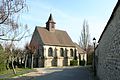 Saint-Denis
 -
 War memorial
 -
 Grande Rue
 -
 Belfry
 -
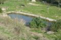 Pond
Pond


| Authority control databases: National |
|---|