Sample Page

Original file (445 × 336 pixels, file size: 26 KB, MIME type: image/jpeg)
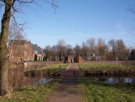
Summary

Description
English: Heemstede park ‘Het Oude Slot’. The park is situated at the site of the former castle ‘Heerlijkheid Heemstede’, or ‘Huis te Heemstede’, at a strategic position on mouth of the Spaarne river on the Haarlem lake (since 1853 pumped dry and called the Haarlemmermeer polder). Photo from the west side of the moat around the castle site.
Date
Source Own work
Author Jane023
Object location52° 20′ 24.39″ N, 4° 37′ 51.91″ E Kartographer map based on OpenStreetMap.View this and other nearby images on: OpenStreetMapinfo

Licensing

Public domain I, the copyright holder of this work, release this work into the public domain. This applies worldwide.
In some countries this may not be legally possible; if so:
I grant anyone the right to use this work for any purpose, without any conditions, unless such conditions are required by law.

Captions

Add a one-line explanation of what this file represents

Items portrayed in this file

depicts

Slot Heemstede

creator

some value

object of statement has role: photographer
author name string: Jane023
Wikimedia username: Jane023

copyright status

copyrighted, dedicated to the public domain by copyright holder

copyright license

released into the public domain by the copyright holder

location of creation

Heemstede

inception

15 January 2007

source of file

original creation by uploader

coordinates of depicted place

52°20’24.38783″N, 4°37’51.91248″E

media type

image/jpeg

ISO speed

100

exposure time

0.002097 second

f-number

4.5

focal length

6 millimetre

File history

Click on a date/time to view the file as it appeared at that time.

Date/TimeThumbnailDimensionsUserComment
current07:45, 16 February 2007Thumbnail for version as of 07:45, 16 February 2007445 × 336 (26 KB)Jane023Heemstede park 'Het Oude Slot'. The park is situated at the site of the former castle 'Heerlijkheid Heemstede', or 'Huis te Heemstede', at a strategic position on mouth of the Spaarne river on the Haarlem lake (since 1853 pumped dry and called the Haarlem

The following 3 pages use this file:

Global file usage

The following other wikis use this file:

Metadata

This file contains additional information, probably added from the digital camera or scanner used to create or digitize it.

If the file has been modified from its original state, some details may not fully reflect the modified file.