Moulsoe is a village and civil parish in the unitary authority area of the City of Milton Keynes, Buckinghamshire, England.[2] It is on the border with Bedfordshire, and just east of the M1, situated about 2.5 miles (4.0 km) ESE of Newport Pagnell, and about 5 miles (8.0 km) NNE of Central Milton Keynes. The main road through the village is the Newport Road coming from the west, changing to the Cranfield Road going east at a bend by the church.
The village name is an Old English language word which means ‘Mul’s hill spur’.[3] In the Domesday Book of 1086 the village was recorded as Moleshou.[4]
There are several old thatched dwellings. Other buildings are of brick apart from some concrete council houses to the west. The parish church dates from the 14th century and is a Grade I listed building.[5] There is an inn, the Carrington Arms, and a village hall, the Millennium Hall.[6]
Caldecote
Caldecote is a tiny hamlet in the parish, notable because of it being mentioned in Domesday.[7]
Gallery
-
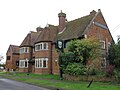
 Yew Tree Cottage, Newport Road
 -
 The Carrington Arms, Cranfield Road
 -
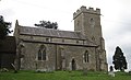 St Mary’s church, view from Newport Road


References
- ^ “PP012 – Age”. NOMIS (Office for National Statisitcs., then select Milton Keynes, then this parish
- ^ “Contact your Parish, Town or Community Council”. Milton Keynes Council. Retrieved 10 October 2020.
- ^ “Key to English place names”. Institute for Name-Studies, University of Nottingham. Retrieved 15 November 2025.
- ^ moulsoe.net/history.htm
- ^ Historic England (17 November 1966). “Church of St. Mary (1212922)”. National Heritage List for England. Retrieved 15 November 2025.
- ^ www.milton-keynes.gov.uk Deprecated link archived 2012-12-23 at archive.today Moulsoe Millennium Hall
- ^ “Buckinghamshire A-E”. The Domesday Book Online. Retrieved 23 November 2022.
External links
![]() Media related to Moulsoe at Wikimedia Commons
Media related to Moulsoe at Wikimedia Commons