Padum (also known as Padam), is a town and the administrative headquarter of the Zanskar district of Ladakh in India.[1] Named after the Buddhist guru Padmasambhava, it was historically one of the two main capitals of the Zanskar Kingdom, the other being Zangla.
Geography
Padum is at the centre of the tri-armed Zanskar River valley.[2] It has an average elevation of 3,669 m (12,037 ft). There are several villages to the north-east of Padum leading to Karsha monastery.
Administration
The sub-divisional capital Padum is a town of the Zanskar sub-division or tehsil in the Kargil district of Ladakh state, India. The Zanskar River flows through the valley from its source at the Drang Drung glacier of the Pensi La. The Zanskar River joins the Lungnak River near Pibiting village.
In August 2024, the Central Government proposed creation of 5 additional districts in the union territory of Ladakh,[3][4] including Zanskar district from the southeastern part of Kargil district with Padum as likely HQ as the demand for Zanskar as new district is more seven decades old.[5] Lungnak or Zangla likely to be upgraded to tehsil for the reduced travel time for the administrative work.
People
Demography
2001 census of India population of Padum town is about 2,000 people.[6] The traditional heart of the village is below the gompa and Palace khar (now in ruins) where two large chortens stand above old buildings.
Culture
Padum is largely inhabited by people of Tibetan descent who follow Tibetan Buddhism. There is also a sizable Muslim population that’s been established for several centuries who share several aspects of Zanskari culture and origins.[7]
Tourism

A number of notable Buddhist monasteries are located near Padum, including Bardan Monastery and Karsha Monastery and the newly built Dalai Lama Photang. The Phugtal Monastery is accessible from here. It is a day’s trek from Dorzang, the end of the road leading from Padum.[8] Chadar trek passes through Padum.
Padum has several hotels, homestays and restaurants for tourists. Padum has a post office, internet cafes and telephone booths.
Connectivity
Transport

Nearest airports are Kushok Bakula Rimpochee Airport at Leh and Kargil Airport.
Jammu Tawi railway station, the nearest railway station, is 750 km south. Under construction Bhanupli–Leh line will have a railway station at Debring about 150 km southeast of Padum.
The Nimmu–Padum–Darcha road (NPD Road) connects Padum directly to Leh in the east and to Darcha (on NH3 Leh-Manali Highway) in Himachal Pradesh. The 235 km (146 mi) long 2-lane NH301 Padum-Pensi La-Kargil Highway connects Padum to Kargil city (on NH1). A road (now NH301) was constructed in 1980 from NH1 at Kargil over Pensi La, which is 235 km away. The 145 km road to Darcha passing through Shinkula pass is now operational, connecting to the Manali-Leh Highway. A bus operates[clarification needed] between 1 June and 30 September, after which the Manali–Leh (NH21) highway is normally closed.[citation needed] Other roads, including the NH1 highway from Leh to Srinagar via Kargil, remain open until the end of October.
Internet and phone
Airtel[9] has started providing its mobile services in Padum since 2023. Jio Has started providing its 4G connectivity from 2020, and now Padum is also connected to 4G network.
Gallery
-
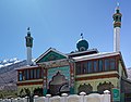 Jama Masjid in Padum.
 -
 Looking south to Padum and Pibiting from Karsha Monastery.


See also
References
- ^ Historic milestone for Ladakh: Five new districts notified in Ladakh; taking total districts to seven, 27 Apr 2026.
- ^ Osada et al (2000), p. 298.
- ^ “Ladakh Gets 5 New Districts Amid Demand For Statehood, PM Modi Lauds Move”. ABP Live. 26 August 2024. Retrieved 9 November 2025.
- ^ “MHA announces five new districts in Ladakh”. The Times of India. 26 August 2024. ISSN 0971-8257. Retrieved 9 November 2025.
- ^ Ladakh-based Buddhist association demands district status for Zanskar, India Today, September 4, 2019.
- ^ Osada et al (2000), p. 298.
- ^ Deboos, Salomé (2023). Homeland Or Religion? Personal Identity Building in Zangskar, Indian Himalayas. Brill. pp. 1–23. ISBN 978-90-04-54470-3.
- ^ “Phugtal Monastery”. Archived from the original on 19 November 2015. Retrieved 19 November 2015.
- ^ “Airtel connects Zanskar Valley in Kargil district with superfast Airtel 5G Plus”.
Bibliography
- Janet Rizvi. (1996). Ladakh: Crossroads of High Asia. Second Edition. Oxford University Press, Delhi. ISBN 0-19-564546-4.
- Osada et al. (2000). Mapping the Tibetan World. Yukiyasu Osada, Gavin Allwright, and Atsushi Kanamaru. Reprint: 2004. Kotan Publishing, Tokyo. ISBN 0-9701716-0-9.
- Schettler, Margaret & Rolf (1981). Kashmir, Ladakh & Zanskar. Lonely Planet Publications. South Yarra, Victoria, Australia. ISBN 0-908086-21-0.
External links
- Photos of Padum
- Images taken at the Karsha Monastery, near Padum Archived 2 April 2015 at the Wayback Machine
| State symbols | |||||||||||||||||||
|---|---|---|---|---|---|---|---|---|---|---|---|---|---|---|---|---|---|---|---|
| History |
| ||||||||||||||||||
| Administration | |||||||||||||||||||
| Geography |
| ||||||||||||||||||
| Human settlements | |||||||||||||||||||
| Culture |
| ||||||||||||||||||
| Tourism and wildlife |
| ||||||||||||||||||
| Transport |
| ||||||||||||||||||
| Infrastructure |
| ||||||||||||||||||
| See also |
| ||||||||||||||||||